No. 99509
Dahlen Castle
Germany
CastleRuin18th century
No. 52774
Castle · Germany
No. 52774 · 51.827 N, 13.256 E
Quick summary
Burg Bärwalde is a castle in Germany with origins associated with the 14th century.
See all castles in GermanyBurg Bärwalde stands in Meinsdorf, Niederer Fläming, Germany; the first known builders at the site were Slavic communities who created an earthwork there in the tenth or eleventh century.
That early Slavic mound was reshaped in the thirteenth century as settlement and fortification patterns in the region changed. Who later founded the stone castle is not recorded with certainty. The text names possible founders as rulers from Saxony or Brandenburg and identifies Bishop Wichmann of Magdeburg as a candidate for early development of the site. By the fourteenth century local lords of Bärwalde were part of the retinue of the Margrave of Brandenburg, the family of Slawtitz (also recorded as Slautitz) appears in documents in 1366, and the site is first called a fortress in 1375.
Ownership continued to shift in later centuries. In the fifteenth century the von Wollenfels (Waldenfels) family held the castle as a fief. Around 1470 the property passed to a Leipzig family. During the seventeenth century the estate was divided in parts, and by the start of the eighteenth century five different owners held portions of the Bärwalder territory. In 1734 Generalleutnant Gottfried Emanuel von Einsiedel bought and reunited the villages that made up the estate. After his death in 1745 his daughter Sofia Dorothea took over the holdings. On 10 February 1780 Joachim Erdmann von Arnim acquired the estate for 98,000 Taler, and under his ownership the castle was adapted into a stately residence. A pictorial plate produced at Wiepersdorf in 1880 preserves a view dating to about 1784 and serves as documentary evidence for the castle’s appearance in that period.
Following the Congress of Vienna in 1815 the territory of Bärwalde became part of Prussia. After the Second World War the von Arnim family was expropriated and the property was placed under demolition authorization by SMAD Order No. 209. Local farmers removed building materials during that process. The demolition revealed a medieval tower built of bog ironstone; its masonry proved difficult to reuse and the tower remained standing. From 1996 onward the local administrative office initiated measures to stabilise and make the site accessible, and in 1998 the surviving tower received repairs and a new reconstructed roof. A small rest area and an information board were also installed at the site.
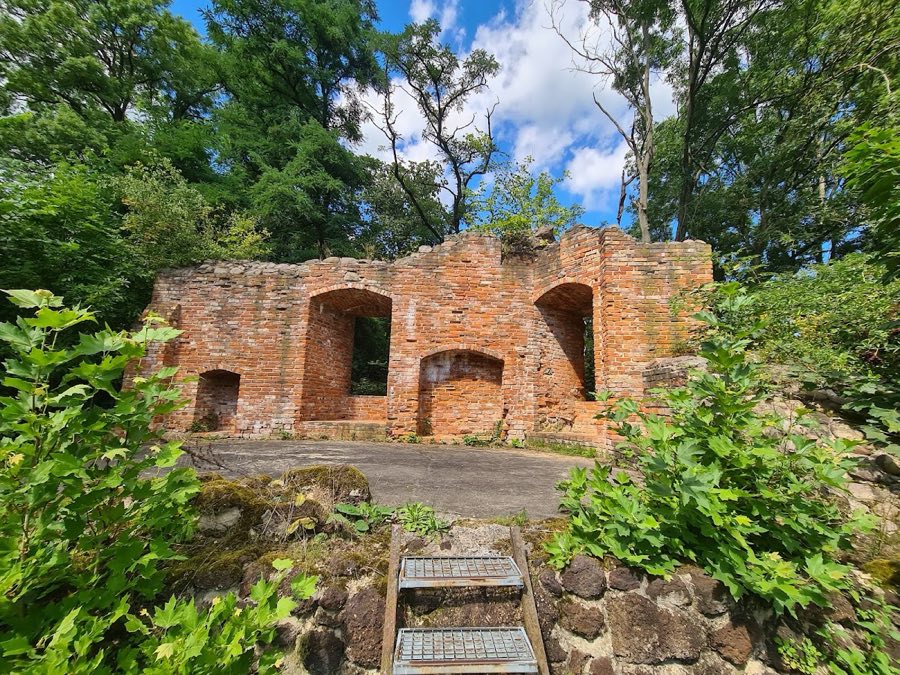
The site is the ruin of a Gothic water castle set on a slight rise and historically surrounded by a water-filled ditch. The complex lay on one of two raised earthworks, each roughly rectangular, measured at about 120 m by 60 m and 120 m by 45 m. Historical images show the main house as a three-storey, L-shaped building with a comparatively steep, red-tiled roof, a depiction used as documentary evidence for the castle’s former form. The state monument register lists the location as a castle ruin and manor park.
The most prominent surviving element is the three-storey residential tower, built of compact bog ironstone. The tower’s masonry largely consists of uncut or only slightly dressed stones set in shallow courses, while a small number of cornerstones are squared. A few window reveals were finished with dressed masonry units. The tower was left standing after postwar demolition because its stone was hard to reuse; it was reinforced and given a reconstructed roof in 1998, so today the structure is upright and partially repaired.
Adjacent to the tower are the remains of two internal rooms. One is an elongated chamber that originally carried a barrel vault; that vaulted space survives only as a ruin. A second room lies at right angles to the first, and its fragmentary walls mark the plan of the former residential range. These structural traces record how living and vaulted service spaces were arranged in relation to the tower before later alterations.
Modifications and later use are visible in the site’s fabric and setting. The tower’s postwar survival and its late twentieth-century repair represent two distinct phases of intervention. The approach to the rise is lined by a double row of chestnut trees leading from the village, and the grounds around the ruins remain open rather than enclosed in the early twenty-first century. An on-site information board and a small rest area accompany the conserved remains.
No. 99509
No. 61825
No. 51264
No. 31696
Comments
Comments for Burg Bärwalde will require a verified account before posting.
We'll send a verification link before your first comment is published.