
No. 58382
Castel Nanno
Italy
PalaceRuin14th century
No. 10884
Castle · Italy
No. 10884 · 46.269 N, 11.112 E
Quick summary
Castel San Pietro (Ton) is a castle in Italy with origins associated with the 14th century.
See all castles in ItalyCastel San Pietro stands in Ton, Italy, and was erected by the Thun family, a medieval noble house.
Construction took place in the latter part of the 1200s, with the main defensive tower and the inner defensive walls dating to the final quarter of that century. The site first appears in surviving documents in 1321. Proposals that the location began as a Roman installation have been advanced by some, but that claim has been challenged as unsustainable.
During the 1300s and 1400s the castle appears repeatedly in feudal records. Members of the Thun family, including Guarimberto III and his heirs, are named in fourteenth-century investitures. Bishops of Trient, among them Georg von Liechtenstein, Alexander von Masowien and Johannes von Hinderbach, issued feudal grants and investitures connected with the fortress across the fifteenth century. In 1337 the lords of Arz laid siege to the castle during the Nonsberg noble feud; in about 1338 surviving documents first record the Thun being enfeoffed with the site.
From the second half of the 1400s the Thun appointed a castellan to hold the place on their behalf. The small stronghold took on new uses by the mid-1500s, serving largely as a hunting residence and as an armoury. On 23 April 1504 Francesco De La Chiesa, Titular Bishop of Drivastum and suffragan of the Prince-Bishop of Trient, consecrated a chapel there, dedicated to Saint Peter. The chapel received liturgical legacies in the 1600s and still appears in visitation records into the 1700s, with the last attestation in 1766. In 1525 Sigismund von Thun strengthened the castle garrison and reinforced the walls in reaction to the unrest of the peasant war.
The fortress declined through the 1600s and the chapel was abandoned early in the 1700s. On the Atlas Tyrolensis of 1774 the site is recorded as a ruined castle, and it is shown as a ruin in an 1846 drawing. Official records continued to list the property as a Thun fief in 1851. Ownership changed in the twentieth century, the site being sold in 1926 to the Bohemian line of the Thun family and later conveyed to the Counts Martini of Mezzocorona, who are recorded as the current owners.
The ruins occupy the narrow tip of a rock spur on the left bank of the Noce River at about 864 metres above sea level, stretching in a northwest to southeast direction for roughly 40 to 45 metres and averaging 15 to 17 metres across. The complex follows the shape of the rocky promontory and preserves masonry from different building phases, with the oldest elements clustered toward the centre.
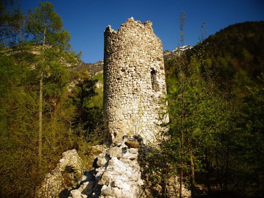
At the heart of the site stands the circular main tower, a cylindrical keep whose base diameter measures about 5.8 to 6.0 metres. Its masonry was laid in locally quarried limestone and the surviving wall thickness reaches approximately 1.40 to 1.45 metres. The tower’s entrance sits several metres above the former ground level and the preserved portion of the structure rises to about 11.5 metres; reconstructions have estimated that its original stature may have been near fifteen metres. This central tower and the inner line of defence date to the late 1200s and appear as the earliest built components.
Encircling the core, the inner defensive wall was built with a modest thickness of around 50 centimetres and formed an enclosure with an area near 475 square metres and an overall run of about 90 metres. Later, an outer circuit of fortification was added, with remains indicating a wall roughly 80 centimetres thick that enclosed about 300 square metres. The outer defence includes the scant remains of a shell-shaped tower in the northwest sector and the footprint of a narrow gateway of about one metre in width. The outer wall and the shell tower reflect fourteenth-century construction and show a technique distinct from the older inner works. In several wall fragments narrow arrow or bow slits remain visible.
On the eastern side of the spur fragments of later buildings survive. Foundations associated with the castle chapel are visible, including the apse whose diameter measures approximately three metres; the chapel is documented as dedicated to Saint Peter and appears in records from the early sixteenth century onward. The western flank of the rock falls steeply to the Torrente Rinassico, providing a strong natural defence. The castle stands within visual range of several other valley fortifications and towers above a track along the Rinassico that has traditionally been identified as a Roman road linking the left side of the Nonstal with the Via Claudia Augusta.
No. 58382
No. 23741
No. 90209
No. 72862
Comments
Comments for Castel San Pietro (Ton) will require a verified account before posting.
We'll send a verification link before your first comment is published.