No. 27057
Château des Vaux
France
ChâteauRestoredFor rent17th century
No. 85198
No. 85198 · 48.484 N, 1.139 E
Quick summary
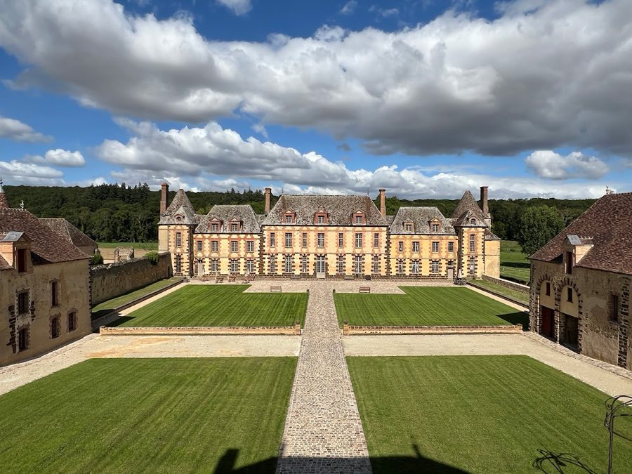
Château de la Rivière is a château in France with origins associated with the 10th century.
See all castles in FranceChâteau de la Rivière, Pontgouin, France is a seventeenth-century château erected by French owners in the early 1600s. Construction began on the site of a fifteenth-century dwelling and the building campaign, concentrated in the first quarter of the seventeenth century, produced a large country house with extensive parks and waterworks. The estate became the long-term seat of the d’Aligre family and its scale, landscaping and agricultural outbuildings mark it as an important provincial noble residence of early modern France.
The property returned to a single owner by the 1590s, and a formal agreement to build the central block appears in a mason’s contract dated 23 January 1617. Carved dates on the walls—1628 on a west corner tower and 1629 on the drawbridge pavilion—show that major masonry work continued through the 1620s. By the time Étienne II d’Aligre died in December 1635 the central living block, the western lateral extension and the drawbridge pavilion with its two towers had been completed. Étienne II held national office as Chancellor of France from 1624 until his removal in June 1626.
After 1637 the heir carried out an extended programme of landscaping and finishing. A private canal was contracted at the end of 1637 and then widened in 1642, while a project to divert the nearby river and fill its old bed took place in 1642–1643. Further building on the east side, the northeast chapel tower and an end pavilion were completed in 1643, and farm buildings and other dependencies were erected in 1644–1645. The dovecote built at this time contained 940 nesting holes, a number that corresponded to the 940 arpents of land held by the family when that structure was created.
Through the eighteenth century the estate continued to be enhanced. A deep masonry icehouse had been constructed by the early 1700s, and a detailed inventory of the château’s furnishings was made in 1740. By inheritance the park measured some fifty-three hectares under Étienne François d’Aligre (1727–1798), and it was enlarged and enclosed by a new boundary wall with local agreement to close a road.
The French Revolution brought administrative change and a threat to landed estates. In January 1790 the National Assembly abolished the old seigneurial jurisdictions, and in 1793 the château, once part of the neighbouring parish, was attached to the commune of Pontgouin. Sequestrations and sales of émigré property followed: the domain was surveyed and a plan and valuation were drawn up in September 1794, and proposals were made later that year to convert parts of the estate to manufacturing uses. An engineer’s report in January 1795 set out proposed uses for the main house and outbuildings should those plans proceed. A family member who had remained in France successfully obtained the lifting of the sequestration on 24 February 1795.
The château remained in the d’Aligre line until 1926, when the marquise d’Aligre died without heirs. The property changed hands in the late 1920s and underwent restoration during that period. It served a temporary institutional role during the Second World War and passed through private ownership in the postwar decades. Further restorations of façades, roofs, gardens, moats, bridges and painted interiors were carried out after 2009. The site was protected as a national historic monument in December 1987, with the protected ensemble extended in 2013 to include dry-moat retaining walls, additional wings and the designed landscape as laid out in 1794.
The château stands on the footprint of a fifteenth-century lodging and presents a long principal façade that reached sixty-six metres in length by the mid-seventeenth century. The original central living block was a single rectangular mass under a hipped roof; measurements recorded in a 1617 contract give its plan as about 23.3 metres by 8.5 metres. Surviving masonry bears dated inscriptions of 1628 on the west corner tower and 1629 on the drawbridge pavilion, which allow the west portion and the entrance pavilion to be linked directly to early works of the 1620s and early 1630s.
Construction employed reused stone from the nearby demolished château de la Plesse together with a brown sandstone taken from land belonging to the bishop of Chartres when he rebuilt his country house above the site. The main block was extended in the 1640s by two wings and narrow end pavilions backed against cylindrical towers, while large rounded towers mark the external corners of the building. One of the entrance pavilion’s flanking towers was known as the bread-oven tower and the other as the dovecote tower; the dovecote itself retains nine hundred and forty nesting holes, matching the family’s recorded landholding at the time of its construction.
Water features and utilities form an important part of the site’s layout. The estate was surrounded by moats fed from the local river and a drawbridge served the main entrance; later descriptions refer to the moats in a dry state and to the loss of the historic drawbridges. A decorative canal designed for the park was begun at the end of 1637, originally over seven metres wide and more than one and a half metres deep, and was widened to twelve metres in 1642; this canal crosses the grounds and was integral to the seventeenth-century landscape scheme.
The service complex and farmyard are arranged around a large courtyard. Outbuildings are laid out symmetrically with hipped roofs and brick-framed dormer windows set beneath triangular pediments. A late-eighteenth-century plan shows a turn-bridge structure, lean-to stores, a store with a turret for coal and a press, cellars and a bread oven, grain and oat barns, cow and sheep accommodations, stables, pigsties, a well in the yard and the farmer’s dwelling at the rear. The wider designed landscape comprised three contiguous parks recorded in 1794: a formal star-shaped park with eight avenues and a central pedestal, a riverside park on the left bank, and a third plot that contained a masonry icehouse more than ten metres deep.
Plans of the ensemble show a fortified-style entrance platform with two flanking buildings (one housing the gardener’s cowshed, the other the gardener’s house with direct access to kitchen gardens), and a smaller château cluster set within its own moats with adjacent pavilions, guard’s lodging and dovecotes. Rear windows of the main house look out over parterres and meadow plots crossed by the Eure and by an old arm that was later filled and called the false river. Exterior walling alternates brick and dressed stone around window openings, attics are lit by dormer windows, and principal ground- and first-floor rooms were planned to admit light through to the central spaces. The ensemble’s façades, roofs, selected interior woodwork, the dovecote and key outbuildings are protected elements of the national historic listing, and later listings include the dry-moat walls, additional wings, a southeastern tower and the historic arrangement of the park and water features as they stood in 1794.
No. 27057
No. 61932
No. 86320
No. 69785
Comments
Comments for Château de la Rivière will require a verified account before posting.
We'll send a verification link before your first comment is published.