No. 19625
Sheffield Castle
United Kingdom
CastleRestored13th century
No. 39112
Castle · United Kingdom
No. 39112 · 53.340 N, 1.777 W
Quick summary
Peveril Castle is a castle in United Kingdom with origins associated with the 11th century.
See all castles in United KingdomPeveril Castle is a medieval fortress located in the village of Castleton, United Kingdom. It was constructed by the Normans in the years following their conquest of England in 1066, serving as a significant stronghold within the region.
The castle’s foundation dates to the late 11th century, under William Peverel, a Norman lord who held extensive lands across Nottinghamshire and Derbyshire. Peveril Castle became the administrative center, or caput, of the Honour of Peverel, overseeing local governance and taxation. This role encouraged economic development in the nearby settlement, which eventually grew into the village now known as Castleton.
In 1155, King Henry II confiscated the Peveril estates from William Peveril the Younger. Henry II is documented to have visited the castle on three occasions between 1157 and 1164, including hosting King Malcolm IV of Scotland during his first visit. The castle’s defenses were reinforced during the Revolt of 1173–1174, with the garrison strength increasing to include twenty knights who also shared duties with the nearby Bolsover and Nottingham castles.
Towards the end of the 12th century and into the early 13th century, the influential Earls of Derby asserted claims to the castle and surrounding lands through marriage. In 1199, William de Ferrers, the 4th Earl of Derby, paid a substantial sum for control of the lordship of the Peak, although the castle itself remained under direct royal authority. In 1216, King John granted the castle to William de Ferrers, but the sitting castellan, Brian de Lisle, refused to surrender it. The king then authorized Ferrers to use force to take control, although no historical record confirms that any attack occurred.
By 1223, the castle had returned firmly to Crown ownership. Throughout the 13th century, Peveril Castle underwent several building campaigns, gradually reaching its complete medieval form by about 1300. The barony eventually passed to John of Gaunt, Duke of Lancaster, in the late 14th century. His tenure is marked by neglect, as he ordered the removal of building materials from the castle for use elsewhere. This action marked the beginning of the fortress’s decline.
For centuries following John of Gaunt’s ownership, the castle remained part of the Duchy of Lancaster’s holdings. Records from the early 17th century describe the structure as severely dilapidated and no longer serving a practical purpose, although it continued to be used for local court meetings until about 1600. The castle’s ownership has stayed with the Duchy to the present day.
Peveril Castle occupies a roughly triangular limestone promontory overlooking Hope Valley, with steep slopes descending sharply from the enclosure, particularly on its southeastern side where near-vertical cliffs drop away. The overall site measures around 90 by 65 meters, with the principal access route approaching from the north along a winding path.
The original entrance was situated on the east side through a modest gatehouse approximately seven meters wide, featuring a passage just two and a half meters long. Although only limited portions survive, details of the stone mouldings suggest that this gatehouse was constructed during the reigns of Henry II or King John in the 12th and early 13th centuries. The enclosing curtain walls present evidence of multiple construction phases, ranging from early Norman stonework laid in an interlocking herringbone pattern, known as opus spicatum, to later repairs and restorations. These walls once supported covered walks along their tops, roughly five meters above the surrounding ground near the gatehouse.
A small tower projecting slightly above the northern curtain wall dates to the 12th century; however, its limited height and projection offered little defensive advantage compared to larger towers built in later periods. Along the southern curtain wall, modern reconstruction has followed the original medieval alignment, incorporating the remains of two round or semi-circular towers that extend outward. One of these towers includes the reuse of Roman tiles taken from the nearby Roman fort of Navio, located roughly three kilometers away, indicating a practical recycling of materials and connection to the area’s earlier history. These towers probably date from the 13th century.
Foundations along the southern wall mark the location of former structures, most likely including an earlier hall and a chapel referenced in a 1246 document. The easternmost building’s remains align roughly east-west, a characteristic orientation for chapels during the medieval period. On the north side of the castle, foundations reveal the position of a large hall, likely used for dining and entertaining important visitors. A 1251 document mentions an “old hall,” which suggests that by that time a newer hall had been built elsewhere, possibly replacing an earlier southern hall.
The areas east of the hall probably housed the kitchen and pantry, although few visible traces remain today. Additional buildings line the western curtain wall and seem to have served as high-status living quarters. Besides the main gateway to the north, there was also a western gate accessed by a bridge crossing a gorge to an outer enclosure. The exact form and purpose of this enclosure have not been excavated but may have functioned as an outer bailey or area for storage and stabling horses.
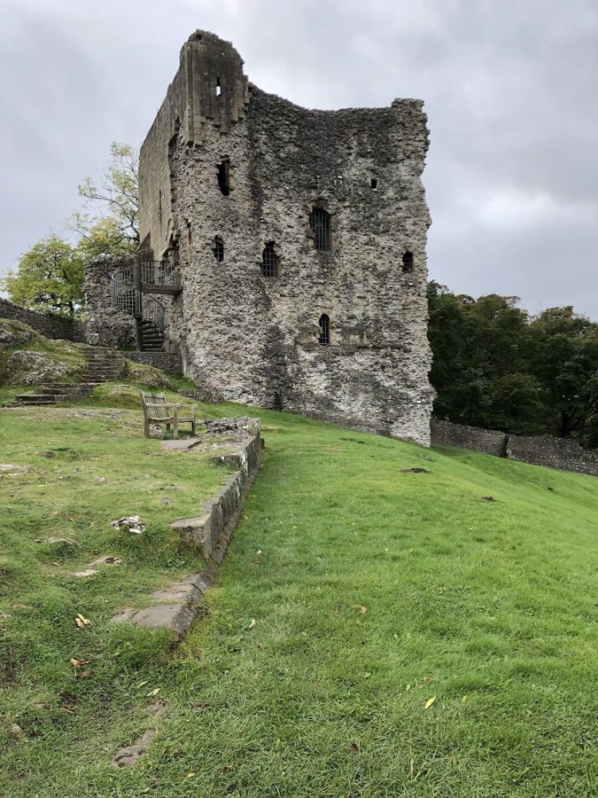
At the castle’s southern corner stands its keep, or donjon, whose construction began around 1176 during Henry II’s reign. This square tower measures less than 12 meters on each side, making it small in comparison with contemporary royal keeps such as those at Dover or Scarborough. The parapets rise approximately 15 meters above the base on the higher side of the ground, but only about 10.5 meters where the terrain slopes downward. The keep’s exterior is now weathered and rough, yet the southeast face retains some smooth facing stone, preserved by the steep cliff that prevented removal, offering a glimpse into the tower’s original finished appearance. A garderobe (medieval toilet) extends from this same southeastern side.
Entry to the keep was originally made on the first floor via an external staircase, a typical Norman design feature. Inside, the first floor probably housed a large public chamber, while the basement served as storage. A narrow staircase in the eastern corner connected the basement level to the parapet walk atop the tower, allowing defenders easy access to the battlements.
The ground within the castle slopes from west to east, and the sources of water for the inhabitants remain uncertain. The castle’s elevated position provided commanding views over key landscape features such as Hope Valley and nearby hills including Treak Cliff, Mam Tor, Black Tor, and Lose Hill. The village situated close by supplied provisions to the castle throughout its occupation.
No. 19625
No. 13791

No. 18142
No. 97208
Comments
Comments for Peveril Castle will require a verified account before posting.
We'll send a verification link before your first comment is published.